Environmental modelling and measures
Environmental modeling aims to represent processes that occur in the real world in space and time. Herein we focus on the processes in agricultural catchments, both within soil and water, including forest and peat areas as well as semi-urban solutions. In addition, models are an integral part of any restoration and/or mitigation and climate change adaptation plans. Therefore, we specifically look for optimal and robust ways to include the effects of mitigation measures, especially nature-based solutions (NBS) into our modeling work. Environmental modeling is widely used within NIBIO to support research and advisory activities.
Models are used to:
- Improve understanding of complex systems – simulate and simplify complex reality
- Provide spatio-temporal extension of the knowledge gained from experimental/monitoring data – predict the unknown in space and time;
- Test the reaction of these systems to changing conditions – testing hypotheses and scenarios;
- Support optimization, planning and decision-making
We divide environmental models into two groups:
- Management models, as their name implies, are used either in elucidating better management practices or in aiding management decisions and planning. Several of the models are described under "Guide to environmental measures in agriculture"
- Research models are used to organize and guide research of a particular system. Models designed for management can certainly utilize concepts from research models but must avoid the complication of them. Research models, however, can be useful for calibrating simpler “top-down” models as recently demonstrated by Raulier et al. (2000).
Our models
Projects
Division of Environment and Natural Resources
OPTAIN: Optimal strategies to retain and re-use water and nutrients in small agricultural catchments
OPTAIN proposes a social and scientific journey toward the increasing and better understanding of the multiple benefits of Natural/Small Water Retention Measures (NSWRM). The Norwegian case study area, Kråkstadelva catchment, is located within the Hobølelva watershed 30 km S-SE of Oslo.
Division of Environment and Natural Resources
DrenKlim: Drainage systems in clay soils inTrøndelag - adaptation to changing climate
With changing hydrological conditions there is need to evaluate the functioning of drainage systems under future circumstances and to highlight possible needs to redesign them.
Division of Environment and Natural Resources
NORDBALT ECOSAFE: Nitrogen and phosphorus load reduction approach within safe ecological boundaries for the Nordic Baltic region
About the project
Division of Food Production and Society
Agricultural mitigation measures and the value of water quality improvements
Agriculture is one of the main sources of water pollution in Norway, and an important contributor to GHG emissions.
Division of Environment and Natural Resources
Hydrologiske strategier for optimalisering av funksjonen til fangdammer i et endret klima
Fangdammer er kjent som effektive tiltak for å redusere forurensning og forbedre vannkvalitet i jordbruksbekker.
Division of Environment and Natural Resources
MARCHES - Methodologies for Assessing the Real Costs to Health of Environmental Stressors
Division of Environment and Natural Resources
ENGAGE: Europe Nutrient Management - Guided Approaches for Greater Export reduction
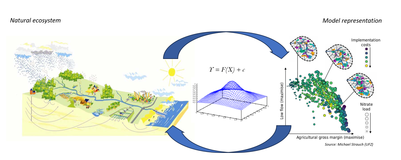
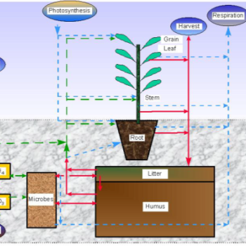
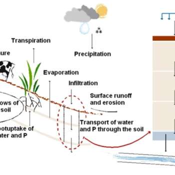
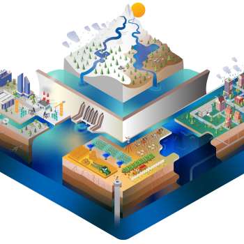
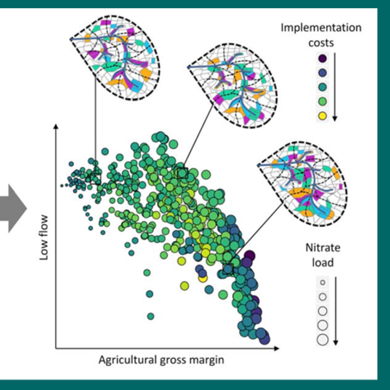
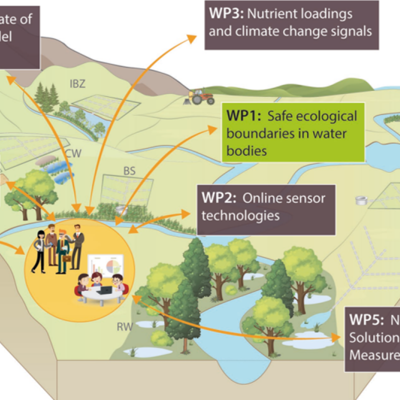
ENGAGE aims to operationalise a novel vision for the future of multi-scale nutrientexport reduction and associated ecosystem services in national andtransboundary/international river basins in Europe by bringing together robuststakeholder engagement strategies with coupled state-of-the-art computationalhydrology techniques and online interactive use-tailored DS tool approaches that integrate remote sensing, socio-economic, governance, and society-change decisionelements.
NORRA: Development of data-modelling system and the decision support tool
The general principles of the water use and protection are established by the Water Act, which is based on the EU Framework Directive on water policy and the Framework Directive on the sea strategy in order to ensure sustainable development and the natural status of water, and keep the quality, amount and regime of surface and groundwater as unviolated by human activity as possible. The aim of both directives is to ensure or acquire a good water status of inland bodies of surface water and coastal waters by 2015 and for the sea by the year 2021.
Division of Environment and Natural Resources
IRIDA: Innovative remote and ground sensors, data and tools into a decision support system for agriculture water management
Efficient agriculture water use is of crucial importance for water resources management. Evapotranspiration is an important part of the water cycle, as it is the sum of evaporation and plant transpiration from the Earth's land and ocean surface to the atmosphere. Consequently, accurately determining evapotranspiration (ET) is the first step for improving irrigation efficiency and productivity and for quantifying the ecosystem water balance.