SWAT+

Research model: SWAT+
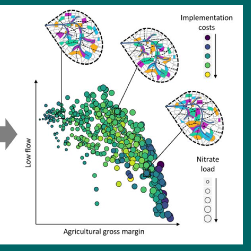
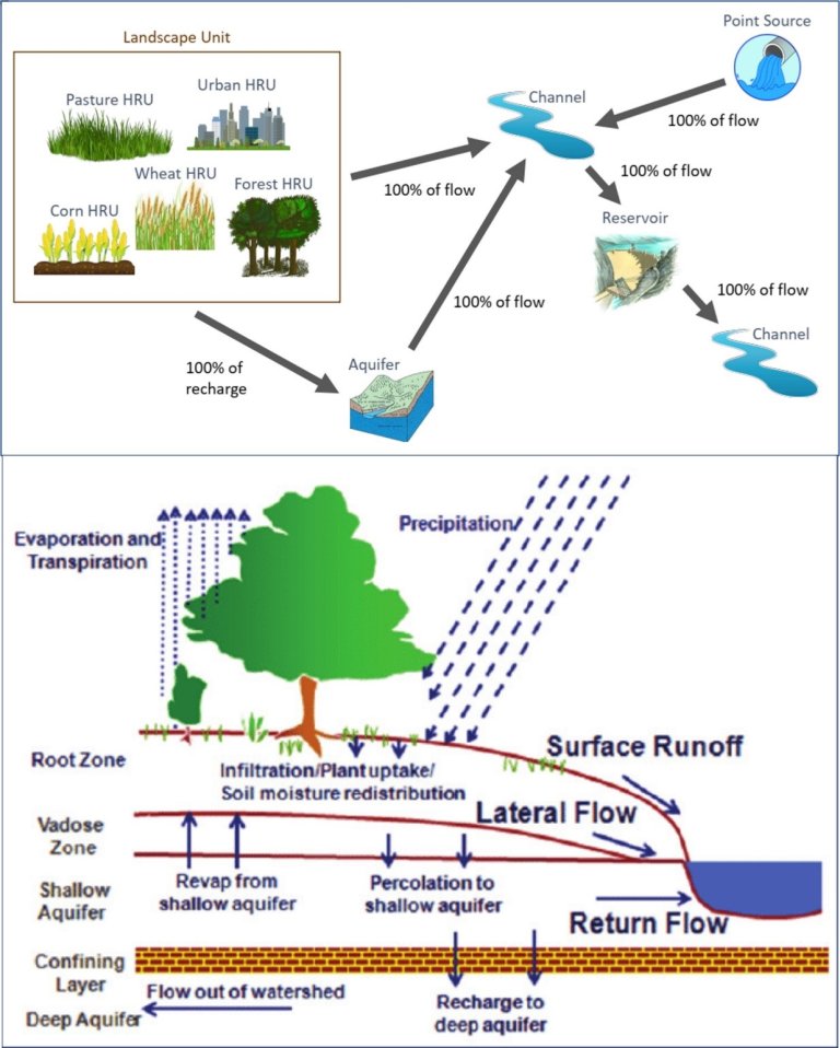
SWAT+, is a completely revised version of the SWAT model (Soil Water Assessment Tool). SWAT+ provides a more flexible spatial representation of interactions and processes within a watershed. This model is widely used in assessing hydrology of agricultural watersheds, soil erosion prevention and control, non-point source pollution control and regional management in watersheds.
Basic specifications of the model:
Name of model | SWAT+ : Soil Water Assessment Tool | ||
About the model |
| ||
Purpose of model | Simulate the quality and quantity of surface and ground water and predict the environmental impact of land use, land management practices, and climate change. | ||
Developer | USDA Agricultural Research Service (USDA-ARS) and Texas A&M AgriLife Research. https://swat.tamu.edu/ | ||
Scale |
| ||
Spatial | Lump, Semi-distributed and distributed | ||
Temporal | Daily and hourly | ||
Process description |
| ||
Model type | Process based | Heat | Yes |
Interception | Yes | Snow dynamics | Yes |
Infiltration & water flow | Yes, SCS curve number | Frozen soil | Yes |
Surface runoff | Yes | Crop growth and rotation | Yes |
Macropore flow | Yes | Nitrogen transport | Yes |
Evapotranspiration | Yes, both potential and actual ET are calculated | Phosphorus transport | Yes |
Artificial drainage and irrigation management | Yes, different options | Particle transport | Yes |
Percolation | Yes | Pesticide transport | Yes |
Other: | Groundwater flow, lake, reservoir, wetland and pond operations. | ||
Contacts

Csilla Farkas
Research Professor
-
Division of Environment and Natural Resources
(+47) 948 14 727 csilla.farkas@nibio.no Office Location: Ås O43
Mojtaba Shafiei
Post Doctor
-
Division of Environment and Natural Resources
(+47) 412 48 742 mojtaba.shafiei@nibio.no Office Location: Ås O43
Links
SWAT+ websiteContacts
Csilla Farkas
Research Professor
-
Division of Environment and Natural Resources
(+47) 948 14 727 csilla.farkas@nibio.no Office Location: Ås O43
Mojtaba Shafiei
Post Doctor
-
Division of Environment and Natural Resources
(+47) 412 48 742 mojtaba.shafiei@nibio.no Office Location: Ås O43
Publications
Authors
Christoph Schürz Natalja Čerkasova Csilla Farkas Attila Nemes Svajunas Plunge Michael Strauch Brigitta Szabó Mikolaj PiniewskiAbstract
This SWAT+ modelling protocol was designed for guiding model setup development and model calibration in 14 European case study sites participating in the modelling component of the EU funded research and innovation project OPtimal strategies to retAIN and re-use water and nutrients in small agricultural catchments across different soil-climatic regions in Europe (OPTAIN). These 14 case studies are small agricultural catchments (ranging in size from 21 to 254 km2 ) located in three biogeographical regions of Europe and 12 different countries. The main topic of OPTAIN are Natural/Small Water Retention Measures, which are a relatively new concept. These are small and multi-functional measures for the retention/management of water and nutrients in the landscape, thus addressing drought/flood control, management of water quality problems, climate change adaptation, biodiversity restoration, etc.
Authors
Alexander Melvold Engebretsen Rolf David Vogt Marianne BechmannAbstract
Effects of mitigation measures in agriculture on abating eutrophication are difficult to evaluate by assessments of catchment monitoring data. Estimates of improved water quality by specific agricultural Best Management Practices (BMPs) are therefore often dependent on simulation modeling. A main objective was thus to assess the probable reductions in total phosphorus (TP) loading achieved by implemented agricultural mitigation measures. The case-study site was a catchment in southeastern Norway. Simulation modeling was conducted by use of The Soil and Water Assessment Tool (SWAT). The aim of this present study was to understand the model uncertainty associated both with calibration/validation (baseline) and TP loading scenarios based on BMP. The modeled decrease in TP loading by the set of implemented BMPs was assessed by comparing simulated baseline output with output where the set of abatement actions were removed. The model was set up for the years 2006–2010 and calibrated against observed monitoring data, including daily discharge, sediment- and TP fluxes. Model simulations were performed including and excluding the implemented set of mitigation measures. The simulated set of mitigation measures include decrease in amount of phosphorus fertilization, establishment of vegetated buffer strips along streams and constructed wetlands in the water courses, no autumn tilling and removal of point TP sources from scattered dwellings. Model calibration and uncertainty estimation are performed using an algorithm for Sequential Uncertainty Fitting (SUFI2; ver. 2). Probabilistic risk for given magnitudes of increased TP loading if existing BMPs were not implemented was assessed. Using this novel approach it was possible to state, with a 80th percentile confidence level, that the average annual TP loading would have been about 26% higher if no mitigation measures were implemented in the catchment. This was possible to assess even though the difference between baseline and BMP scenario was not significant.
Authors
Hans Thodsen Csilla Farkas Jaroslaw Chormanski Dennis Trolle Gitte Blicher-Mathiesen Ruth Grant Alexander Melvold Engebretsen Ignacy Kardel Hans Estrup AndersenAbstract
No abstract has been registered
Authors
Alexander Melvold EngebretsenAbstract
No abstract has been registered
Authors
Alexander EngebretsenAbstract
No abstract has been registered
Authors
Johannes Deelstra Csilla Farkas Alexander Engebretsen Sigrun Kværnø Stein Beldring Alicja Olszewska Lars NesheimAbstract
Authors
Johannes Deelstra Csilla Farkas Alexander Engebretsen Sigrun Kværnø Stein Beldring Alicja Olszewska Lars NesheimAbstract
A good understanding of the hydrology and its implementation in models is a prerequisite to facilitate decision making relative to the implementation of water management - and farming practices. This paper presents the results of the application of 5 hydrological models in the Skuterud catchment.
Authors
Johannes Deelstra Csilla Farkas Alexander Engebretsen Sigrun Kværnø Stein Beldring Alicja Olszewska Lars NesheimAbstract
Presnetasjon model resultater Skuterud
Authors
Johannes DeelstraAbstract
Swat workshop, Bioforsk. 20 - 21/5/2009
Authors
Helen FrenchAbstract
Vansjø-Hobøl var et av nedbørfeltene som ble brukt til modellering av næringsstoff transport i EU prosjektet EUROHARP (2002-2005). EUROHARP (ledet av NIVA) var et prosjekt som hadde som mål å sammenlikne ulike modeller som brukes i ulike land i Europa for å estimere kilder til diffus forurensning eller for bergning av mengde nitrogen og fosfor som tilføres overflatevann. Ni ulike modeller ble testet i Vansjø-Hobøl. Modellene, og instituttene som har kjørt modellene, som ble testet er: NL-CAT(ANIMO/SWAP/SWQN/SWQL) ved ALTERRA, Nederland, MONERIS ved FV-IGB, Tyskland, NOPOLU ved IFEN / BETURE-CEREC, Frankrike, Source Apportionment ved NERI, Danmark, SWAT ved EC-JRC / NTUA / IRSA-CNR, Italia, Hellas og Spania, REALTA ved KMM, Irland, N-LES CAT ved NERI, Danmark, TRK(SOILNDB/HBV-N) ved SLU / SMHI, Sverige, EveNFlow ved ADAS, Storbritannia. Alle tilgjengelige data fra nedbørfeltet til Vansjø-Hobøl ble stilt til rådighet for modellørene. To målestasjoner for vannføring og næringsstofftransport (nitrogen og fosfor) var tilgjengelige i nedbørfeltet: Hobøl elva v. Kure og Mosselva. Selv om dette nedbørfeltet har relativt mye data sammenliknet med andre norske lokaliteter var det flere av modellene som manglet viktig informasjon, som f.eks. grunnvannsstand, og jordbeskrivelser for skogsområder (som dominerer i nedbørfeltet). En annen utfordring var at for den ene stasjonen ble vannkvalitet og vannføring målt på ulikt sted. Felles for alle modellene er at de har en rekke parametere som beskriver særtrekk ved nedbørfeltet de modellerer. Disse parametrene må justeres slik at de modellerte resultatene stemmer best mulig med observasjonene i feltet. Alle modellgruppene skulle først kjøre modellen uten å justere på parameterene, som om feltet ikke hadde noen tidsserier med observasjoner av næringsstofftransport. Kun TRK, NL-CAT, SWAT og Evenflow kunne utføre en slik test, bare TRK og SWAT har vist resultatene. Resultatene etter kalibrering illustrerer at alle modellene er relativt gode til å modellere vannføringen i området, total Nitrogen på en årlig basis simuleres tålelig bra, mens modelleringen av fosfor er problematisk. Det er svært liten forskjell mellom modellene til tross for at kun TRK og Moneris har evaluert sin modell som egnet for simuleringer av nordiske forhold.