Csilla Farkas
Seniorforsker
(+47) 948 14 727
csilla.farkas@nibio.no
Sted
Ås - Bygg O43
Besøksadresse
Oluf Thesens vei 43, 1433 Ås (Varelevering: Elizabeth Stephansens vei 21)
Sammendrag
Small retention ponds are increasingly recognised as effective nature-based solutions for managing hydrological extremes in Norway’s agricultural catchments. Typically located in upper catchment areas or at the forest–agriculture interface, these ponds temporarily store runoff during intense rainfall events and snowmelt. In addition to flood mitigation, they provide important co-benefits by reducing soil erosion and sediment transport and by protecting agricultural drainage systems from erosion and overflow during extreme events, thereby supporting long-term soil productivity. Although individual storage volumes are limited, their cumulative impact at the catchment scale can be substantial when retention ponds are strategically distributed across the landscape. This study investigates the potential effects of small retention ponds using process-based hydrological modelling with SWAT+ to support catchment-scale climate adaptation planning in a Norwegian agricultural catchment. SWAT+ enables an improved representation of hydrological connectivity between managed landscapes and the stream network through its flexible spatial structure and rule-based management algorithms. The model is calibrated using a constraint-based approach that integrates both soft and hard data to represent streamflow and sediment dynamics in the Lierelva catchment. Multiple retention ponds are implemented to assess their cumulative effects on streamflow and sediment transport. Finally, the study discusses key challenges associated with modelling catchment–NBS interactions using SWAT+.
Sammendrag
Det er ikke registrert sammendrag
Sammendrag
Det er ikke registrert sammendrag
Divisjon for miljø og naturressurser
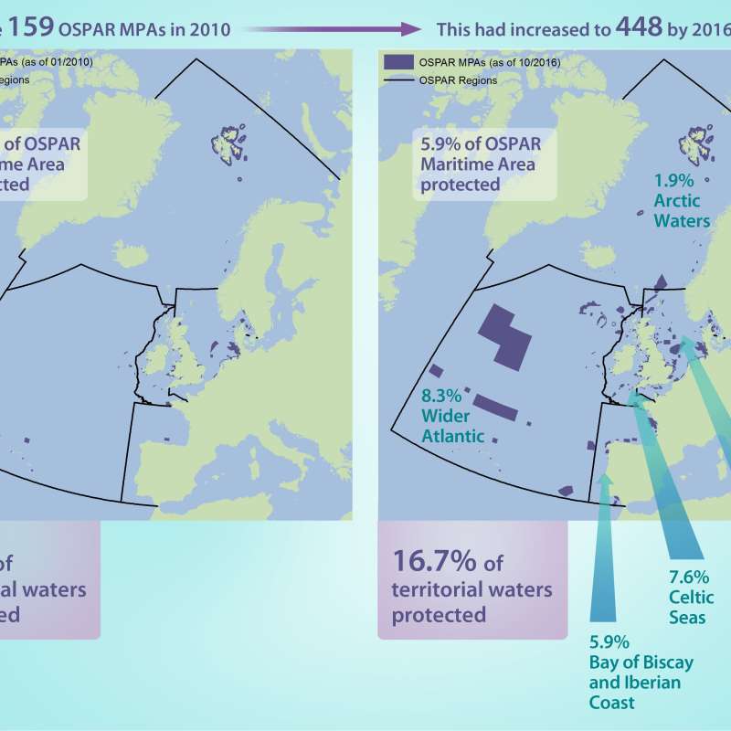
Riverine Inputs and Direct Discharges - RID
The Comprehensive Riverine Inputs and Direct Discharges (RID) programme aims to monitor and assess all inputs and discharges of selected contaminants to the OSPAR maritime area and its regions that are carried via rivers into tidal waters, or are discharged directly into the sea, for example through sewage pipelines or activities like aquaculture inputting substances directly.

Divisjon for miljø og naturressurser
MARCHES - Methodologies for Assessing the Real Costs to Health of Environmental Stressors
Divisjon for miljø og naturressurser
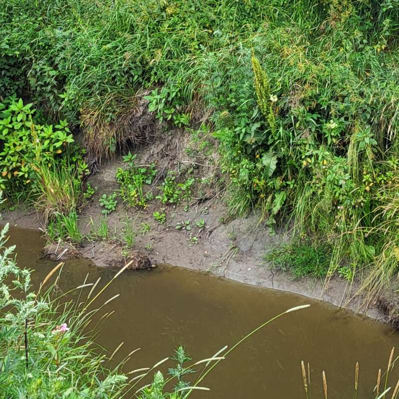
Kråkstadelva: Tiltak mot flom og erosjon
Kråkstadelva er et jordbruksvassdrag som har utfordringer med oversvømmelser og erosjon i elvekantene. Utfordringene skyldes dels klimaendringer med økt og mer intens nedbør, dels ulike inngrep i nedbørfeltet. I dette prosjektet vil vi ha søkelys på hvilke tiltak som kan iverksettes oppstrøms i nedbørfeltet for å redusere problemer med kanterosjon og oversvømmelser nedstrøms.
Divisjon for miljø og naturressurser
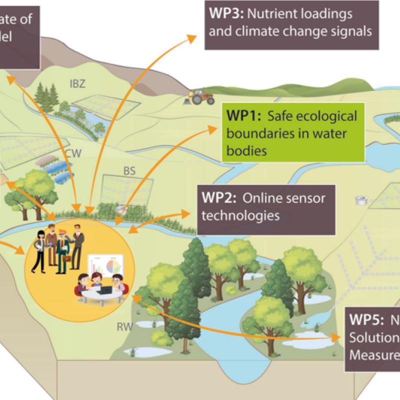
NORDBALT ECOSAFE: Nitrogen and phosphorus load reduction approach within safe ecological boundaries for the Nordic Baltic region
About the project
Divisjon for miljø og naturressurser
ENGAGE: Europe Nutrient Management - Guided Approaches for Greater Export reduction
ENGAGE aims to operationalise a novel vision for the future of multi-scale nutrientexport reduction and associated ecosystem services in national andtransboundary/international river basins in Europe by bringing together robuststakeholder engagement strategies with coupled state-of-the-art computationalhydrology techniques and online interactive use-tailored DS tool approaches that integrate remote sensing, socio-economic, governance, and society-change decisionelements.
Divisjon for miljø og naturressurser
Hydrologiske strategier for optimalisering av funksjonen til fangdammer i et endret klima
Fangdammer er kjent som effektive tiltak for å redusere forurensning og forbedre vannkvalitet i jordbruksbekker.
Divisjon for matproduksjon og samfunn
Agricultural mitigation measures and the value of water quality improvements
Agriculture is one of the main sources of water pollution in Norway, and an important contributor to GHG emissions.

Divisjon for matproduksjon og samfunn
Tiltak i landbruket og verdien av forbedret vannkvalitet
Landbruket er en av de viktigste kildene til vannforurensing i Norge, og samtidig en stor bidragsyter til klimautslipp.