
Division of Forest and Forest Resources
PathFinder - Towards an Integrated Consistent European LULUCF Monitoring and Policy Pathway Assessment Framework
End: aug 2026
Start: sep 2022
More information
Official project websiteProject participants
Johannes Schumacher Rasmus Astrup Stefano Puliti Clara Antón Fernandéz Ryan Bright Morgane Merlin Zsofia KomaPartners
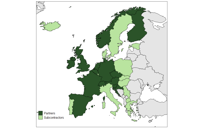
Albert-Ludwigs University Freiburg (ALU), Germany
National Institute of Geographic and Forest Information (IGN), France
Vrije Universiteit Amsterdam (VUA), Netherlands
Thünen Institute of Forest Ecosystems (TI), Germany
Croatian Forest Research Institute (CFRI)
Natural Resources Institute Finland (LUKE)
Federal Research and Training Center for Forests, Natural Hazards and Landscape (BFW), Austria
Slovenian Forestry Institute (GIS)
Czech Forest Management Institute (UHUL)
Technical Research Centre of Finland Ltd. (VTT)
Consejo Superior de Investigaciones Científicas (CSIC), Spain
Center for International Climate Research (CICERO), Norway
University of Göttingen (UGOE), Germany
University of Helsinki (UH), Finland
TreeMetrics (TM), Ireland
Eigen Vermogen van het Instituut voor Natuur- en
Bosonderzoek (EVINBO), Belgium
European Landowners Organisation (ELO), Belgium
Institut Européen de la Forêt Cultivée (IEFC), France
Finnish Meteorological Institute (FMI)
Associated partners:
Swiss Federal Research Institute for Forests Snow and Landscape Research (WSL)
University of Bristol (UB), United Kingdom
Joint Research Center (JRC), Belgium
European Environmental Agency (EEA), Denmark
| Status | Concluded |
| Start - end date | 01.09.2022 - 31.08.2026 |
| Project manager | Johannes Breidenbach |
| Division | Division of Forest and Forest Resources |
| Department | National Forest Inventory |
| Total budget | 57492664 |

Publications in the project
Authors
Johannes BreidenbachAbstract
Invited speaker at Symposium Future research in forest monitoring and remote sensing, organized by University Göttingen, Germany
Authors
Johannes BreidenbachAbstract
Invited presentation at breakfast seminar by MEP Stefan Köhler in the EU parliament
Authors
Anna Wöhlbrandt Anabel Onay Ute Bachmann-Gigl Wolfgang Falk Christian Temperli Samuel Aspalter Debojyoti Chakraborty Silvio Schüler Johannes Breidenbach Jonas Fridman Miriam Isaac-Renton Vladimír Šebeň Mitja Skudnik Tzvetan Zlatanov Dominik Thom Eric A. ThurmAbstract
Amid increasing temperatures and extended drought periods, forest managers require comprehensive information regarding the suitability of various tree species under changing climatic conditions. To address this need, we assembled a unique dataset spanning Europe, incorporating multiple data sources such as national forest inventories, forest management plans, and data from ICP Forests. Our database ultimately included over six million individual trees across 860,000 forest plots throughout Europe. Using this extensive dataset, we developed Species Distribution Models (SDM) for 30 and Site Index Models (SIM) for 25 European tree species, the latter limited by data availability. Both model types were used to generate predictions at a spatial resolution of 1 × 1 km for the periods 2011–2040, 2041–2070, and 2071–2100 under climate change scenarios RCP2.6, RCP4.5 and RCP8.5. The model predictions aim to estimate the top height and assess climate suitability across Europe under future climate conditions. One potential application of these models is in a decision support system (DSS) to inform tree species selection and management strategies in the context of climate change. Provided are the models, prediction outputs, and supporting information, as the underlying database is restricted by data use agreements.
Authors
Johannes Schumacher Alessandro Cescatti Gherardo Chirici Giovanni D’Amico Saverio Francini Johannes Hertzler Lauri Mehtätalo Gert-Jan Nabuurs Mats Nilsson Juho Pitkänen Johannes BreidenbachAbstract
The availability of reliable ground-truth data is one of the main bottlenecks for improving high-resolution forest attribute maps from Earth observation data. This is underpinned by the European Union (EU) Forest Strategy for 2030 that underscores the need for harmonized, cross-border forest resource assessments that integrate both remote sensing and field-based National Forest Inventory (NFI) data. However, confidentiality constraints on NFI plot coordinates present a significant barrier to aligning these datasets, thereby limiting the development of unified forest monitoring systems that can fully leverage the potential of Earth Observation data. To overcome these data-sharing limitations we explored the effectiveness of a privacy-enhancing technique, known as Federated Learning (FL), that is a form of distributed computing aimed at preserving the privacy and confidentiality of data owned by different organizations. This methodology has been tested for the collaborative modelling and mapping of forest timber volume across four European countries: Norway, Sweden, Finland, and Italy. We employed a time-series convolutional neural network (CNN) architecture tailored to integrate 40 years of Landsat or 7 years of Sentinel imagery and terrain variables with harmonized NFI data from more than 85,000 sample plots. This model architecture was used for the FL approach and compared to traditional country-specific and centralized modelling strategies. FL models achieved predictive performances comparable to the traditional models, which proofs the effectiveness of the proposed approach. Centralized or global models showed slightly reduced performance compared to the national models, highlighting the value of fine-tuning with local ground-truth data. By aligning with the EU’s forest monitoring objectives, FL facilitates the generation of harmonized models and maps of forest features, like timber volume and biomass, that are critical to support evidence-based forest policy and management. The findings underscore the potential of FL to transform collaborative environmental monitoring, particularly in domains where data confidentiality and interoperability are critical.
Authors
L. Duncanson P. M. Montesano A. Neuenschwander A. Zarringhalam N. Thomas D. M. Minor M. A. Wulder J. C. White E. Guenther T. Feng V. Leitold S. Hancock J. Armston Stefano Puliti A. I. Mandel S. Shah C. Silva M. Purslow J. Bruening Johannes Breidenbach Erik Næsset Svetlana Saarela N. Hunka J. R. Kellner S. P. Healey D. Schepaschenko J. Wallerman C. S. R. Neigh N. Carvalhais R. DubayahAbstract
Forest aboveground biomass Density (AGBD) maps provide important constraints on climate and carbon cycle models and enable the long-term monitoring of carbon stocks. NASA's latest spaceborne lidar instruments provide unprecedented observations of forest structure that are used to compile spatially continuous, locally trained maps of circa 2020 AGB density and stock. To address a geographical limitation of the International Space Station deployed GEDI instrument, herein we map high northern latitude forests with a fusion of NASA's ICESat-2 mission, Harmonized Landsat Sentinel-2 (HLS), and Copernicus GLO-30 topographic data. We report a domain-wide estimate for boreal forests of 72.96 +/− 0.61 Pg AGB. Combining these maps with those of tropical and temperate forests from GEDI products provides a global estimate of 2020 biomass stocks of 593.49 +/− 11.47 Pg AGB. We analyze biomass means and totals across the boreal domain in different land cover types, slope classes, and ecoregions. We compare these products to national estimates of AGB stocks for high latitude countries, finding good general agreement between national reports and EO-based estimates, particularly for countries with robust National Forest Inventories (NFIs) and boreal forests, while underestimation of high AGBD in tall, dense forests remains a challenge for AGBD mapping. Satellite products can be used to support wide area estimation of aboveground biomass, and the maps described here provide insights into carbon stocks, patterns, and dynamics at scales relevant to forest management. These open access data products serve as a baseline to assess future changes associated with drought, fire, insects, deforestation, and degradation.
Authors
Johannes BreidenbachAbstract
No abstract has been registered
Authors
Johannes BreidenbachAbstract
No abstract has been registered
Authors
Johannes BreidenbachAbstract
No abstract has been registered
Authors
Johannes BreidenbachAbstract
Presentation
Abstract
1. Field-based vegetation mapping is important for environmental assessments.Often, the area covered by a species is estimated visually within a reference frame.However, such assessments are prone to observer bias and a large variability. 2. We developed a deep learning pipeline relying on YOLOv8 models to segmentspecies and estimate the percentage cover (%) of Vaccinium myrtillus (blueberry)and Vaccinium vitis-idaea (lingonberry), two key understory species in borealforests. We used 138 nadir and downward-looking images of the forest floorcaptured in correspondence with 50 × 50 cm vegetation sub-plots assessedwithin National Forest Inventory (NFI) plots. First, we trained a bounding-boxframe detection model to crop the image to the same area assessed in the field.Second, we trained an instance segmentation model to classify species. Third,we flattened the class values into a semantic raster and estimated the species-specific cover by pixel counting. 3. We evaluated our method against an independent test set of 156 images andfound a root mean squared error (RMSE) of 8.82% for blueberry and 3.49% forlingonberry and no substantial systematic errors. An additional comparison withocular estimation by various field workers for the same plots showed that themodel estimates were within the range of estimates by field workers 8 out of 9times for blueberry and 7 out of 9 times for lingonberry. 4. The developed method shows promise in reducing observer bias and variabilityin vegetation surveys, thereby improving their consistency while significantlyreducing the time needed for species-specific coverage estimation. This isparticularly beneficial for repeated measurements and monitoring vegetationcover dynamics. However, as the method relies on RGB data, it is limited toestimating the percentage of visible species that are not obscured by others.Expanding the method to include a broader range of cover classes (e.g. grasses,rocks, logs) or species could automate the capture of crucial information
Authors
Daniel Moreno-Fernández Johannes Breidenbach Isabel Cañellas Gherardo Chirici Giovanni D’amico Marco Ferretti Francesca Giannetti Stefano Puliti Sebastian Schnell Ross Shackleton Mitja Skudnik Iciar AlberdiAbstract
Forest biodiversity is a multifaceted term encompassing tree and shrub diversity and the diversity of other life forms such as animals or fungi. Extensive forest monitoring networks such as National Forest Inventories or the International Co-operative Programme on Assessment and Monitoring of Air Pollution Effects on Forest plots have implemented biodiversity-monitoring protocols to satisfy increasing information demands. However, these protocols often evaluate biodiversity through potential biodiversity indicators (e.g., stand structure and deadwood), which may not provide sufficient information on other aspects of the current forest biodiversity status. In this study, we present the forest biodiversity monitoring results and lessons from a cross-country study to support large-scale monitoring systems. We developed, evaluated, and discussed harmonized protocols, mainly focused on birds and mammals, which extend beyond the traditional features captured in large-scale forest inventories. We leverage information from 30 intensively monitored plots established in six European countries to achieve these goals. The protocols were helpful in recording data that could be used to reproduce biodiversity-related attributes such as measures of forest structure, regeneration, deadwood features, and bird and mammal diversity. Specifically, field data on trees was used to describe structural features of forests such as stand composition and forest complexity. In contrast, composition and regeneration data provided helpful information for other biodiversity indicators. Data gathering to monitor bird and mammal diversity requires revisiting the plots, which involves greater economic investment and human effort. Once the bird and mammal data have been collected, advanced algorithms could facilitate and enhance the efficiency of the analyses. To optimize the monitoring efficiency, we recommend including these two new biodiversity assessments in a subset of extensive survey plots. Furthermore, using standard guidelines for these new assessments across all countries would facilitate the comparison and reporting of statistical data.