Dominika Krzeminska
Head of Department/Head of Research
(+47) 915 98 728
dominika.krzeminska@nibio.no
Place
Ås O43
Visiting address
Oluf Thesens vei 43, 1433 Ås
Biography
I am researcher - modeller and field worker - working in the area of hydrogeology, soil stability, landslides and natural based solutions.
I am landslide hydrologists (PhD), Environmental Engineer (MSc) and certified EHS specialist (PostGrad). My research are dedicated to natural hazard and disaster analysis, with the focus on soil stability, buffer zone efficiency and the influence of preferential flow paths on landslides hydrology. My main research activities included: hydrogeological site monitoring (field measurements, data collection), data processing (ArcGIS, MatLab, PCRaster, MicrosoftExcel) and modelling (STARWARS, LISEM, BSTEM, PROSYS II), as well as presentation of the findings (orals, posters, technical reports).
Besides the main research I was actively involved in organising workshops, conferences and (on line) intensive courses, creating platform to exchange the knowledge, data and share all kind of experience. This activates made me aware of the importance of proper communication and collaboration between researchers, authorities and stakeholders.
My research and managerial experience comes from participations in several EU funded and international projects: MOUNTAIN-RISKS (2007–2010, FP6), ECOU-PREF (2006-2008), ANR CATTEL TRIGGERLAND (2007-2010) and SAFELAND (2008-2011, FP7), PREDHYPO (2015-2016), RECARE (2014-2018, FP7), BUFFERKLIMA (2017-2019).
Key competences:
- spatial data analysis and data integration
- monitoring and analysing of hydrological systems (field and laboratory measurements campaign)
- data processing (ArcGIS, MatLab, MicrosoftExcel)
- modelling (STARWARS, LISEM, BSTEM, PERSIST)
- scripting (PCRaster, FORTRAN)
- presentation (oral and poster)
- technical reports
- academic writing
- project management
Authors
Julia Szulecka Ingrid Nesheim Federica Monaco Anne-Grete Buseth Blankenberg Veronika Čápová Natalja Čerkasova Jovita Mėžinė Joana Eichenberger Kinga Farkas-Iványi Marie Anne Eurie Forio Petr Fučík Martyn N. Futter Marek Giełczewski Wiesława Kasperska-Wołowicz Piroska Kassai Gregor Kramberger Dominika Krzeminska Tatenda Lemann Michael Strauch Brigitta Szabó Artūrs Škute Felix Witing Antonín ZajíčekAbstract
There is strong evidence that ecosystem-based approaches, such as Natural/Small Water Retention Measures (NSWRMs) can be an important solution to problems associated with managing water quality and quantity, soil erosion, and nutrient loss. Moreover, they deliver multiple co-benefits such as increased biodiversity, climate change adaptation and mitigation, alongside aesthetic and recreational functions. However, despite their apparent advantages and significant political momentum for their expanded deployment, implementation of NSWRMs remains slow. This study asks why this is the case and employs a methodologically rigorous variant of the SWOT framework combining qualitative and quantitative (scoring and cluster analysis) elements to assess the exact barriers and potentials for increasing the NSWRMs’ implementation across Europe. The empirical analysis draws on case studies of fourteen small watersheds distributed across twelve European countries to explore the factors affecting the NSWRMs adoption, evaluate their relative importance, and identify necessary intervention areas for their better uptake. Our findings indicate that the main drivers for NSWRMs implementation are high knowledge availability through formal and informal networks, as well as support through advisory services. On the other hand, the main hindrances are inadequate financing schemes but also uncertain societal attitudes and perceptions. Financing schemes rarely account for indirect costs, and bureaucratic procedures further discourage practitioners from pursuing these measures. Negative attitudes are linked to mismatched time horizons as well as the gap between theoretical benefits and practical implementation challenges.
Abstract
Rapporten dokumenterer tømming av-, renseeffekt i- og sannsynlige tilførselskilder til Skuterud fangdam, som ble etablert for å redusere avrenning av jord og fosfor fra jordbruksarealer til Østensjøvannet, Akershus fylke. Fangdammen består av en sedimentasjonsdam og to våtmarksfiltre, og utgjør 0,051 % av nedbørfeltets areal og 0,09 % av jordbruksarealet i nedbørfeltet. I perioden 2003-2020 ble det samlet opp og fjernet ca. 1140 tonn sedimenter og ca. 1100 kg total fosfor fra fangdammen. Store partikler sedimenterte i sedimentasjonsdammen, mens de minste partiklene sedimenterte i våtmarksfiltrene. Korrelasjonen mellom innhold av leire og total fosfor (og total fosfor og P-AL) var god, noe som viser viktigheten av beplantede våtmarksfilter med tilstrekkelig areal og oppholdstid til at små partikler kan synke til bunns og holdes tilbake. Sedimenter fra sedimentasjonsdammen hadde samme egenskaper som jordprøver fra bekkekanten, noe som tyder på at kilden var kanterosjon i bekken. Jordprøver fra åker og kantsoner langs fangdammen hadde høyere innhold av leire enn sedimenter fra våtmarksfiltrene, likevel var fosforinnholdet mye lavere. Tidligere studier har vist at jordbruksjord oppstrøms fangdammen hadde langt høyere næringsinnhold enn jordbruksjord langs bekken, noe som tyder på at fangdammen ble tilført partikler fra erosjon av mer næringsrik jord oppstrøms i nedbørfeltet.
Abstract
Fertilizers and pesticides contribute to the pollution of water resources. The areas along streams are affected by climate change as stream bank failures often occur following floods or during prolonged rainfalls. In addition to BMP (best management practices) on the fields, grassed cover buffer zones are one of the most common measures for improving water quality in Norway’s agricultural catchments. Increased focus on buffer zones is important in a future climate perspective, both for food production, natural diversity and water quality. The efficiency of vegetation cover is composed of a variety of factors; therefore, effectives of these measures are to a large degree site specific. Recently, increased attention is given to the buffer zones efficiency, depending on both conditions in the catchments and the design of the buffer zones itself. However, most research is focusing in investigating the effect of buffer zones looking mostly at the surface runoff. According to our knowledge there is no previous research investigating the efficiency of the buffer zones with flower mixture. We focus on these types of vegetation as they also stimulate increased biodiversity. Moreover, previous investigations show that more than 50% of simulated runoff infiltrates into buffer zones with grass and bushes, while within buffer zones with trees there all the water infiltrates into the soil. Herein we show the results of 3 years monitoring surface runoff from buffer zones with different types of plant cover (grass and flower mixture). The idea was to monitor real live surface runoff from the field with autumn tillage (as “worst case scenario”). The results show significant differences, especially in the runoff quality. The visual differences are confirmed by water quality analysis.

Division of Environment and Natural Resources
MARCHES - Methodologies for Assessing the Real Costs to Health of Environmental Stressors
Division of Environment and Natural Resources
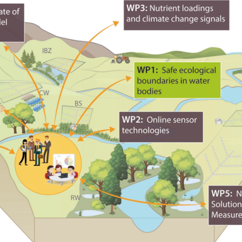
NORDBALT ECOSAFE: Nitrogen and phosphorus load reduction approach within safe ecological boundaries for the Nordic Baltic region
About the project
Division of Environment and Natural Resources
ENGAGE: Europe Nutrient Management - Guided Approaches for Greater Export reduction
ENGAGE aims to operationalise a novel vision for the future of multi-scale nutrientexport reduction and associated ecosystem services in national andtransboundary/international river basins in Europe by bringing together robuststakeholder engagement strategies with coupled state-of-the-art computationalhydrology techniques and online interactive use-tailored DS tool approaches that integrate remote sensing, socio-economic, governance, and society-change decisionelements.