National Monitoring of the Agricultural Landscape
In 1998, NIBIO established a programme of ground-level re-photography called "Flashback — Norwegian Landscapes in Retrospect." Over a period of five years, a first-round of photographs were taken at 130 randomly selected 1 x 1 km2 plots. The plots are located throughout the entire country, and they include agricultural land.
Between 25 and 40 photographs were taken at each plot, and each image was archived with its map coordinates, cardinal direction and the focal length of the lens. The resulting several thousands of photographs provide a basis for repeat photography, to illustrate landscape continuity and change. Many plots have already been re-photographed.
New Photographs of Former Landscapes
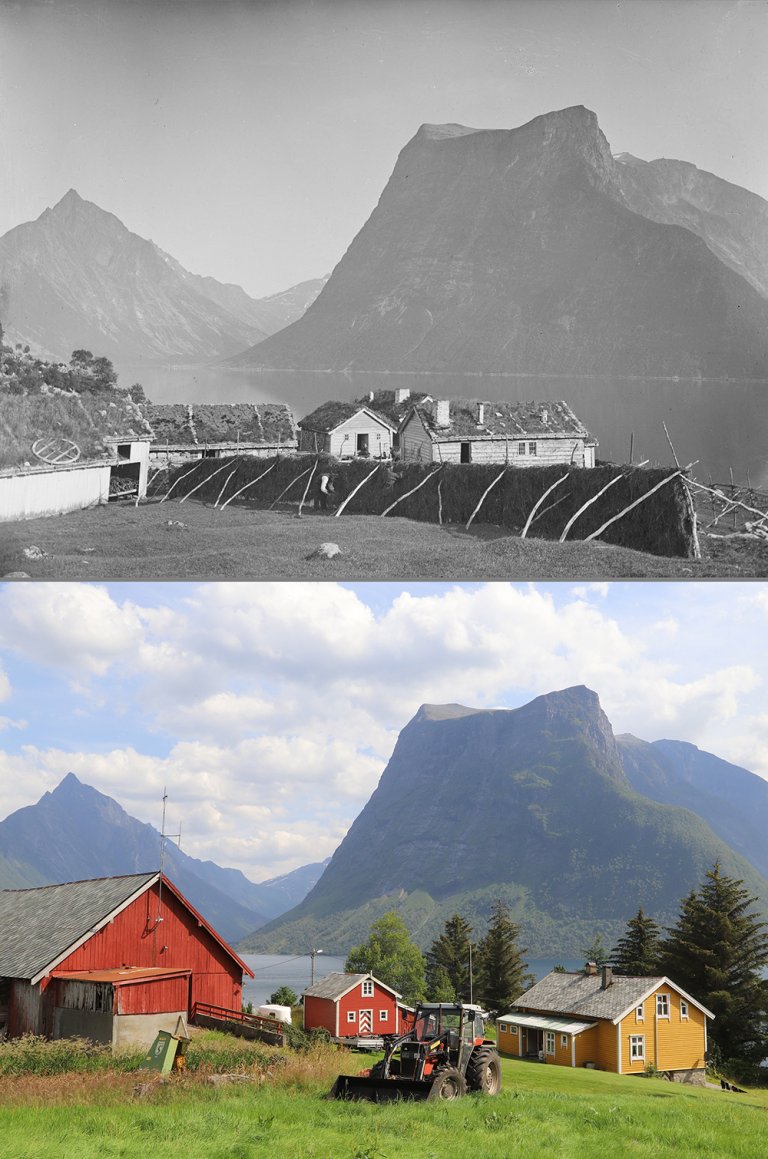
Since 2002, the Flashback Programme has been supplemented with re-photography of old landscape photographs. The old landscape images have been sourced from different photographers, including both public institutions and private individuals. The exact viewpoint of each photograph has been re-visited and a new photograph has been taken in the same direction as the old one.
Two photographers in particular inspired repeat photographs throughout the country: Axel Lindahl (photographs dated 1884–1896) and Anders Beer Wilse (photographs dated 1901–1948). The Norwegian Museum of Cultural History (Norsk folkemuseum) holds the rights to use these images and is a main partner of NIBIO in the Flashback Programme. All these pairs of photographs are eventually transferred to the archives of the Norwegian Museum of Cultural History.
Greater Knowledge about Landscape Changes
In line with the European Landscape Convention, our intention is to expand knowledge and raise awareness about different types of landscape changes. Therefore, also many newer NIBIO images are being re-photographed, and the dates and coordinates of their viewpoints recorded. We highlight how a variety of changes in key social domains can be linked to changes in the landscape. Such changes may be driven by developments in agriculture, urban and suburban areas, transport, trade and industry, changes in population size or composition, and management of outdoor recreation, cultural heritage and natural resources.
The photo pairs show changes, regardless of whether they are perceived to be negative or positive. By using the photographs together with other information from systematic monitoring programmes (e.g. the Norwegian Monitoring Programme for Agricultural Landscapes or the National Forest Inventory), we can provide information about how common the changes are that we see in the photographs or highlight changes that are representative for particular landscape types.
The photo pairs shall be available to everyone. Many pairs of images have been used in lectures and newspapers, websites in Norway and abroad, magazines and TV programs. Since 2005, Flashback has had its own summer series in the national agricultural newspaper Nationen, and from 2024, NIBIO has received funding from the Savings Bank Foundation (Sparebankstiftelsen) DnB to make photo pairs easily accessible and searchable for use in, for example, school assignments. This is done through NIBIO's photo archive and the map portal Kilden. The funds also cover a collaboration with teachers and pupils in lower secondary school, among others to develop three easy-to-use guides for re-photography, first-time photography, and finding photo pairs in NIBIO's databases, respectively.